Renderosity Forums / Vue
Welcome to the Vue Forum
Forum Moderators: wheatpenny, TheBryster
Vue F.A.Q (Last Updated: 2024 Dec 30 8:14 pm)
Subject: Geocontrol 2 Vue tutorial
Thanks! Very nice and clear instructions.
LVS - Where Learning is Fun!
http://www.lvsonline.com/index.html
Quote - Nice tutes. Thanks for them. Just wondering, why do you use procedural instead of importing the bitmap directly onto a large terrain. I think the bitmap approach would render much faster.
Immensly faster but Vue dastardly kills all the highest frequencies in the terrain (I would call this a BUG without esitation), giving a too smooth appearance.
Bye!!!
P.S.: absolutely no guarantee of fixes, but I am working on a terrain enhanment tool to counter-act Vue bug.
GIMP 2.7.4, Inkscape 0.48, Genetica 3.6 Basic, FilterForge 3 Professional, Blender 2.61, SketchUp 8, PoserPro 2012, Vue 10 Infinite, World Machine 2.3, GeoControl 2
Chipp, this method was recommended by Cajomi, the creator of Geocontrol. But your question is interesting and I will add a short explanation in the text.
Fantasy pictures,
free 3d models, 3d tutorials
and
seamless textures on Virtual Lands.
Nifty tutorial - all I have to do is learn how to use Geocontrol properly :)
My Freebies
Buy stuff on RedBubble
Quote - why do you use procedural instead of importing the bitmap directly onto a large terrain.
You can import a 4k x 4k 16 bit map onto a procedural terrain of any resolution* and the function will not lose any detail. This lets you preview with a 256 x 256 procedural terrain for speed, bump it up to 1024 or whatever to preview fine detail, take it back down, and then crank everything up to maximum for the final render.
*The function editor is independent of the final resolution.
It is not a question of height resolution (8/16 bits). Vue uses the true shape of the heightfield if it is handling a procedural terrain while it DELIBERATELY smoothes the normal terrains.
As an experiment, create a terrain with a terrain generator striving for finely detailed structures and save the result as a 16 bit TIFF. Then create, using the same TIFF, two terrains, a normal one and a procedural one, put them side by side and render. You will see that the procedural terrain maintains the fine structures while the nornal one has been smoothed out.
This is purely academical if you cover your terrain with ecosystems or have textures which kill fine details; otherwise, e.g. for desertic scenes with "bland textures" the difference is absolutely striking.
I don't know whether I will have time today to do so, but I plan to create a side-by-side comparison image to be posted in the gallery to nail this bug with a visual proof this bug.
GIMP 2.7.4, Inkscape 0.48, Genetica 3.6 Basic, FilterForge 3 Professional, Blender 2.61, SketchUp 8, PoserPro 2012, Vue 10 Infinite, World Machine 2.3, GeoControl 2
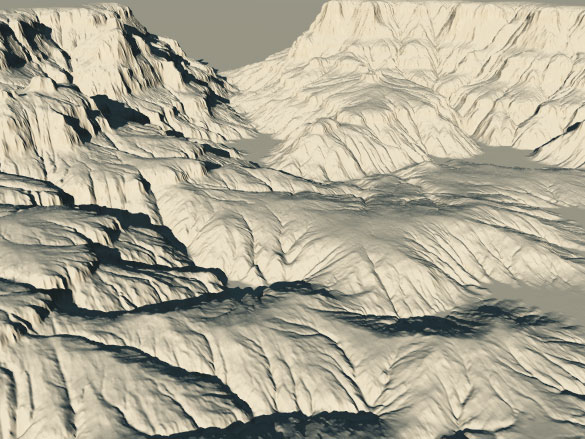
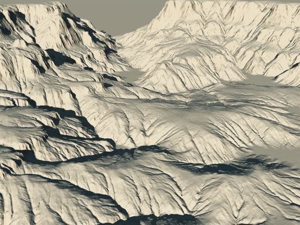
To show the difference, here is an example with the same image file.16 bit tiff, 2048*2048 size. The procedural one looks a bit different due to the 1.01 resize.
Bitmap
Procedural
Fantasy pictures,
free 3d models, 3d tutorials
and
seamless textures on Virtual Lands.
Yes, I used the same file and the "classic" terrain resolution is 2048*2048.
I think there may be more differences with 4096 maps or if you zoom on the terrain a bit. But it is true that with a proper texture, there might be few differences.
I will make a series of benchmarks with or without textures to see which option is the best in terms of quality / render speed.
Fantasy pictures,
free 3d models, 3d tutorials
and
seamless textures on Virtual Lands.
I have uploaded a render in my gallery to show the different behaviour of standard and procedural terrains w.r.t. sharpness.
The 1.01 scale trick is necessary to remmove artifacts which often appear on the "top" and "right" borders of the image when using procedural terrains.
Bye!!!
GIMP 2.7.4, Inkscape 0.48, Genetica 3.6 Basic, FilterForge 3 Professional, Blender 2.61, SketchUp 8, PoserPro 2012, Vue 10 Infinite, World Machine 2.3, GeoControl 2
Quote - Did you match the terrain resolution to your 16 bit TIFF? And, how big was your source file in pixels? Your results differ from what offrench posted, but then you post processed your image.
He clearly stated, in the gallery, that he was using the same 16bit TIFF using the two different techniques, image loading and texture projection-procedural.
I think you shouldn't have posted a 2048 picture, it's logical that we won't see much of a difference there. Only 4096 has true details.
Quote - Woah! 4096! Try loading a couple of THOSE terrains in Vue... For that size (which I've never used, even on my highest terrain models), I suppose procedural would be the way to go...but I wouldn't be surprised if you got plenty of OOM errors ;-)
Who is to say, that I'd do 4096 on distant terrains??
I have imported and rendered 4+ 4096 terrains simoultanously without a problem.
Where's your problem? :P
Quote - Did you match the terrain resolution to your 16 bit TIFF? And, how big was your source file in pixels? Your results differ from what offrench posted, but then you post processed your image.
First of all, I am not a pro, but neither am I a complete idiot.
I used the GeoControl2 project file mentioned in the tutorial pages at the beginning of this thread. I generated a 1024x1024 16 bit TIFF. I created a 1024x1024 standard terrain and a procedural one, both using the same TIFF. W.r.t. postprocessing... obviously I post processed the whole image, so the differences are all due to Vue handling of terrains.
If you have GC2 and Bryce, just try to create a .PGM and import it into Bryce. You will see that the terrain is highly detailed.
The moral of this story is very simple. Vue, when creating standard terrains, performs an unwarranted low pass filtering which eliminates the highest frequencies of the terrains. I suppose that this is a relic of an old age, like the 256x256 default standard terrain size, when computers had much less resources and, if you tried a very coarse terrains without smoothing, you would experience dreadful artifacts.
I have done another test (which may be I will post next week): I created, using WM2 Beta, a kind of unsharp mask filtering on the terrain values. Using this enhanced TIFF, which counters Vue smoothing, standard terrains are as detailed as procedural ones. People who have a 16bit capable image editor can try this way even if they have not (yet) own WM2.
GIMP 2.7.4, Inkscape 0.48, Genetica 3.6 Basic, FilterForge 3 Professional, Blender 2.61, SketchUp 8, PoserPro 2012, Vue 10 Infinite, World Machine 2.3, GeoControl 2
Alex,
I am sorry if you thought I inferred you were an idiot. Far from the truth. I did my own studies and created the following renders. Note, these are sections of a much larger render. Zoomed in one can see much more of the detail. See the bottom of my post for observations.
1: 256 x 256 terrain with procedural mapped 2048x2048 16-bit TIFF; 1'08"
2: 2048 x 2048 terrain with procedural mapped 2048x2048 16-bit TIFF; 1'08"
3: 2048 x 2048 terrain with procedural mapped 2048x2048 16-bit TIFF CONVERTED TO REGULAR; 0'30"
4.: 2048 x 2048 with imported 2048x2048 16-bit TIFF; 0'30"
Numbers 1 and 2 were both procedural terrains, with the only difference being base resolution. While they look identical, doing a difference layer in Photoshop of the BMP data showed very slight differences.
Numbers 3 and 4 were not procedural. 3 was created from the original 2048x2048 procedural terrain and number 4 uses the 16-bit TIFF import. It's easy to see your previous assertion of loss of detail is quite apparent here. There's less overall dynamic range of the image interpolation in the imported versus the converted. They rendered in less than half the time the procedurals did.
best regards,
Chipp
Privacy Notice
This site uses cookies to deliver the best experience. Our own cookies make user accounts and other features possible. Third-party cookies are used to display relevant ads and to analyze how Renderosity is used. By using our site, you acknowledge that you have read and understood our Terms of Service, including our Cookie Policy and our Privacy Policy.


I have written a two part tutorial showing how to use Geocontrol 2 terrains in Vue. The first part shows the import export process and the second one deals with the material distribution.
Geocontrol 2 Vue part 1
Geocontrol 2 Vue part 2
I am not sure I have been clear enough in the tutorials, so let me know if there are still obscure things.
I now understand why many tutorials are in video. It takes a long time to make the captures and write all this stuff. And I am sure a video explains things much better. I'll see what I can do for the next one.
Fantasy pictures, free 3d models, 3d tutorials and seamless textures on Virtual Lands.